

3 New Data Sets to Improve Renewable Siting
At Pivvot, we’re constantly looking for new data sets to enhance our platform. From our perspective, the more data the better! And for our clients, more data = great returns.
While we already have hundreds of data sets, we know our customers can benefit from new information when evaluating potential sites for their energy projects. We aim to deliver as much information as possible to our clients, quickly, to inform their development and investment decisions. The more data you have, the better the understanding of your project, and the more return you can get for it later.
We’ve recently added three data sets to our Pivvot library that can help our renewable siting customers.
Hydric Soils
Hydric Soils are now a map layer and in Pivvot Reporting. Identifying the location hydric soils provides an indication of Potential Wetland Soils Landscape (PWSL). Identifying PWSL provides an enhancement to the existing US National Wetland Inventory (NWI) datasets. These data provides earlier and faster insight around the potential construction and engineering risks in your project area.
.png?width=900&name=MicrosoftTeams-image%20(13).png)
What is hydric soil data?
Hydric soil is a soil that formed under the conditions of saturation. This occurs with flooding or ponding during the growing season that produces anaerobic conditions in the upper part of the soil layers. Saturated or regularly flooded soils have high water content and potential high organic matter content making them difficult to construct permanent facilities or assets within. Hydric soils can be used to screen unsuitable terrain for building solar farms, wind turbines, road construction or even the placement of an electric transmission towers or gas/oil pipelines.
Interconnect Queues
The Pivvot data team has gathered, geo-referenced, and published interconnect queues for ISOs (Independent System Operators) located in the contiguous US. The "Interconnect Queue" Pivvot map layer can be accessed in the siting module and as a Pivvot Layer in the Aware application. Interconnect queues allow developers to understand who is ahead of them at a specific interconnection when evaluating potential renewable generation sites.
.png?width=1029&name=MicrosoftTeams-image%20(12).png)
What are Interconnect Queues?
The Interconnection Queue lists the current status of requests for the interconnection of new or uprated (increased capacity) generating facilities in a region or state managed by a Independent System Operator (ISO) or Regional Transmission Authority (RTA). Interconnect Queues allow utilities to process interconnection applications in a fair and orderly manner — typically first-come, first-served.
High Resolution Slope
Pivvot has added USGS LiDAR data to the platform to leverage in usable area calculations and derive a more detailed digital elevation model. The higher resolution data provides more detailed terrain to make more informed decisions on your project
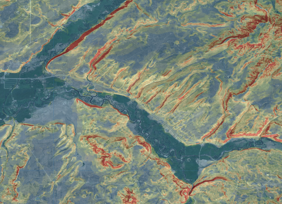
What is High-Resolution Slope?
The USGS provides LiDAR data for selected states across the country. LIDAR stands for Light Detection and Ranging. It is a remote sensing method that uses light in the form of a pulsed laser to measure ranges (variable distances) to the earth from a sensing platform (Airplane, Drone etc.) Pivvot has leveraged USGS LiDar to calculate more accurate elevation profiles and percent slope within our software.
What's Next?
As mentioned above, Pivvot is continuously adding to our data. In the coming week’s we’ll be releasing new data sets including weather events! Keep coming back for details or to talk to one of our data pros, contact us today.