We hear the same thing over and over... Project Developers prospect and find sites that (from a desktop) look like viable, suitable candidates for utility-scale solar projects. But, as soon as pre-construction or the engineering and design team gets their hands on it, issues start popping up.
Often, wetlands can be missed in a desktop review and are uncovered after an environmental firm has been sent out to the field. Slope may not be accurate enough and a greater degree of grading is required than the budget will allow. Sites that appear to have a large buildable area turn out to be not suitable for the project and you're forced to start over.
At Pivvot, we set out to solve these challenges. We've developed a robust prospecting tool and baked-in suitability analysis features that allow project developers to hand off more qualified sites to their engineering teams.
View, Interrogate and Export Specific Constraints
Pivvot's siting tool calculates usable area and displays it immediately. While all that data is downloadable, our customers said they needed a better understanding exactly where and why the area is constrained. Our latest enhancement will now include individual layers for each constraint used in the usable area calculation - both within the application and in the KMZ and data package!
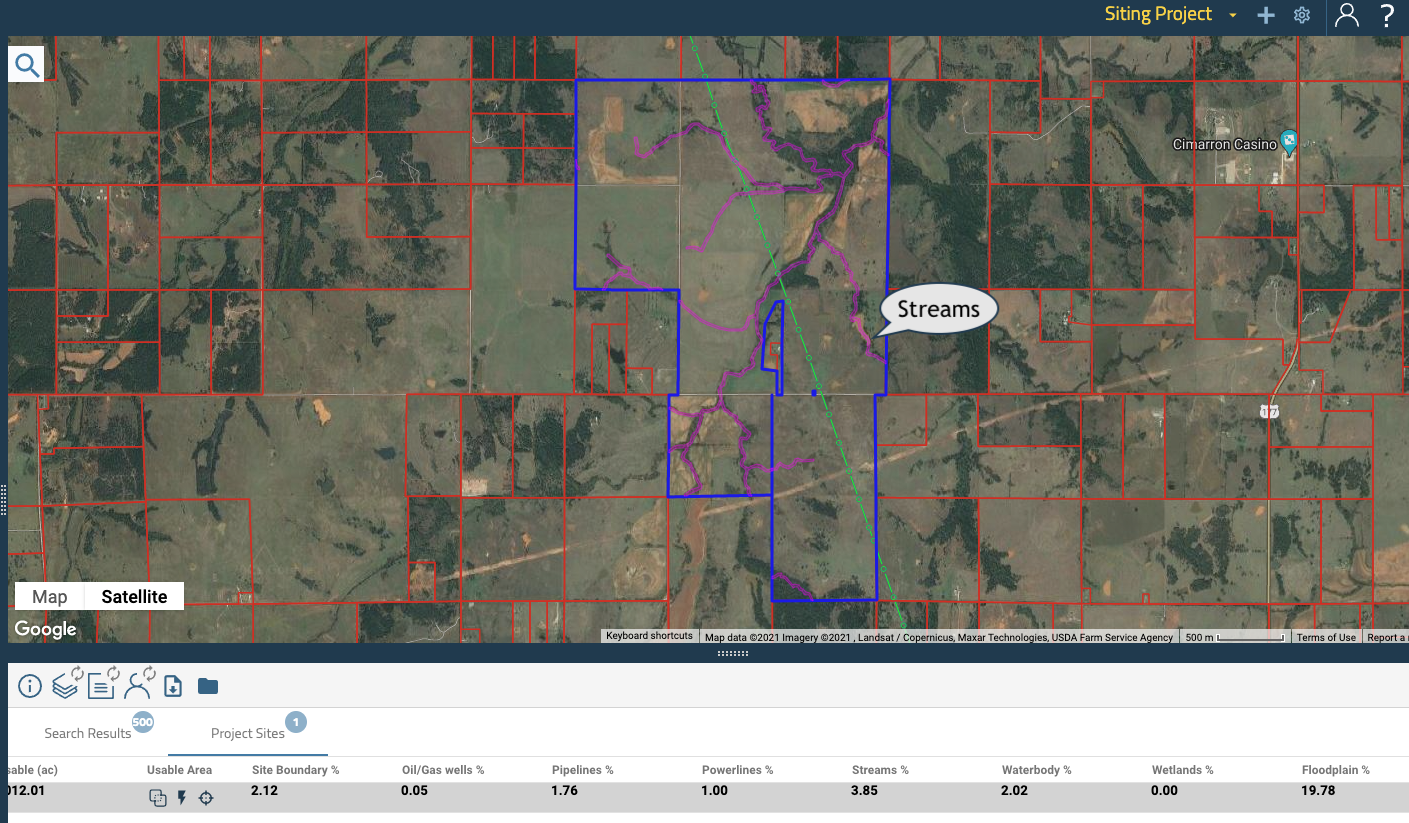
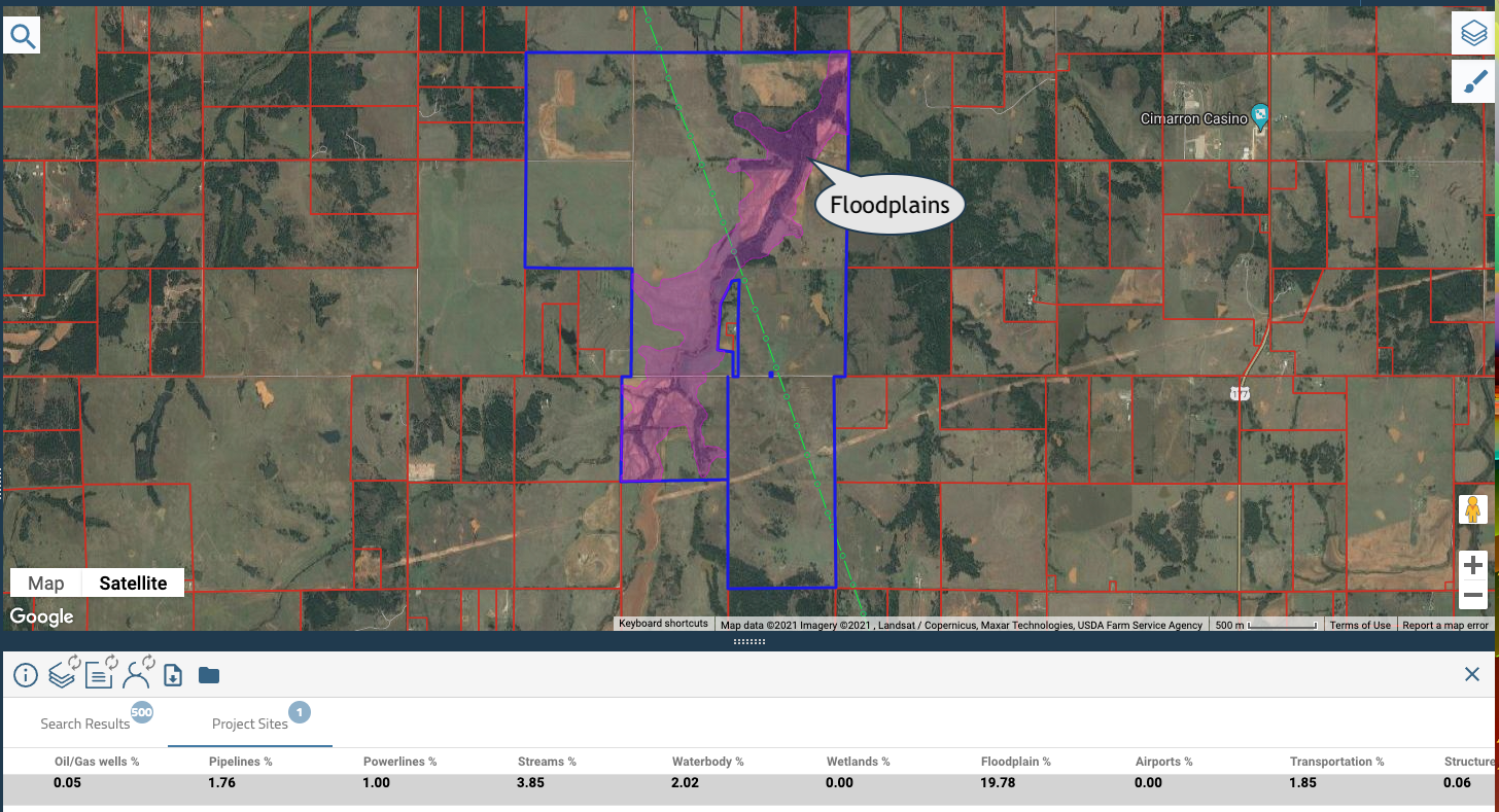
In the Pivvot platform, you can now toggle between individual constraint layers. In the examples below, the constraints are represented in purple and we're able to understand exactly what data is constraining the area.


When downloaded, the user can better interrogate the data to see the exact impact of an individual constraint without having the other constraints visible.
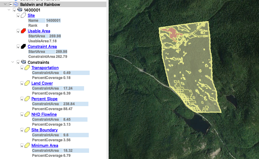
Below is an example of the individual constraint layers with the values of project impact included as viewed in Google Earth. In the data package, a feature class called “Constraints” will now be included in the .fgdb to better understand constraints outside of the platform.

So, when project developers are ready to pass their sites off to pre-construction or engineering and design teams, it's helpful to have a data package that can be interrogated in multiple formats. Engineering teams can begin to evaluate array design and consider grading and other constraints at a more granular level.
But what about the actual data? What are we doing to better support site suitability with data?
Pivvot has recently added data layers that could provide pre-construction and engineering with a deeper understanding of site suitability.
Hydric Soils Data
Hydric soil is a soil that formed under the conditions of saturation. Saturated or regularly flooded soils have high water content and potential high organic matter content making them difficult to construct permanent facilities or assets within.
While publicly available wetland data can give us one view of potential wetlands, turning on the hydric soils layer could reveal additional areas that an environmental firm would flag as wetland and unsuitable.
Save yourself a bundle by identifying this layer before you send out a field crew!
.png?width=900&name=MicrosoftTeams-image%20(13).png)
High-Resolution Slope Data
Pivvot now uses USGS LiDar to calculate more accurate elevation profiles and percent slope within our software. LIDAR stands for Light Detection and Ranging. It is a remote sensing method that uses light in the form of a pulsed laser to measure ranges (variable distances) to the earth from a sensing platform (airplane, drone etc.)
Compared to the standard information typically provided, higher resolution slope allows engineers to get within a greater degree of accuracy on expected percent slope. Again, you can save money by evaluating the slope at a more granular level before you send out a geotechnical team.
Can We Get Subject Matter Expert Review?
Yes! Pivvot has recently partnered with Terracon to offer Stage1 as part of your Pivvot subscriptions. Stage1 combines Terracon’s extensive project data, compiled over its 50-plus year history, with environmental and geotechnical data sources from more than 700 public and private map sources, and curates it with the local experience of professionals from more than 150 offices to provide remote, site-specific site research without the cost, time and risk associated with intrusive exploration and investigation.
To learn more about Pivvot, our siting solution or our partnership with Terracon, schedule a demo. We'd love to talk to you!

